


Tarnac Puy Murat

taguette
User
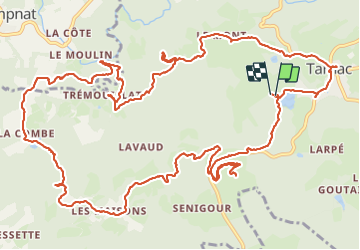

Length
19.3 km

Max alt
795 m

Uphill gradient
597 m
Km-Effort
27 km

Min alt
566 m

Downhill gradient
595 m
Boucle
Yes
Creation date :
2023-08-18 05:57:07.361
Updated on :
2023-08-18 19:36:43.127
4h45
Difficulty : Medium

FREE GPS app for hiking
 SityTrail
IGN / Geographical institutes
SityTrail Plus
The world is yours!
About
Trail Walking of 19.3 km to be discovered at New Aquitaine, Corrèze, Tarnac. This trail is proposed by taguette.
Positioning
Country:
France
Region :
New Aquitaine
Department/Province :
Corrèze
Municipality :
Tarnac
Location:
Unknown
Start:(Dec)
Start:(UTM)
417184 ; 5058801 (31T) N.
Comments