


Tarnac 2

taguette
User
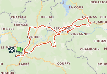

Length
22 km

Max alt
818 m

Uphill gradient
445 m
Km-Effort
28 km

Min alt
639 m

Downhill gradient
446 m
Boucle
Yes
Creation date :
2023-08-20 05:59:00.845
Updated on :
2023-08-20 10:55:11.632
4h52
Difficulty : Difficult

FREE GPS app for hiking
 SityTrail
IGN / Geographical institutes
SityTrail Plus
The world is yours!
About
Trail Walking of 22 km to be discovered at New Aquitaine, Corrèze, Tarnac. This trail is proposed by taguette.
Positioning
Country:
France
Region :
New Aquitaine
Department/Province :
Corrèze
Municipality :
Tarnac
Location:
Unknown
Start:(Dec)
Start:(UTM)
417136 ; 5058812 (31T) N.
Comments