


Ronceveau

Vinceneux
User

Length
19.3 km

Max alt
1429 m

Uphill gradient
826 m
Km-Effort
29 km

Min alt
709 m

Downhill gradient
579 m
Boucle
No
Creation date :
2023-08-22 05:30:30.731
Updated on :
2023-08-22 11:40:49.861
6h07
Difficulty : Very difficult

FREE GPS app for hiking
 SityTrail
IGN / Geographical institutes
SityTrail Plus
The world is yours!
About
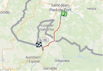
Trail Walking of 19.3 km to be discovered at New Aquitaine, Pyrénées-Atlantiques, Uhart-Cize. This trail is proposed by Vinceneux.
Positioning
Country:
France
Region :
New Aquitaine
Department/Province :
Pyrénées-Atlantiques
Municipality :
Uhart-Cize
Location:
Unknown
Start:(Dec)
Start:(UTM)
643298 ; 4775415 (30T) N.
Comments