


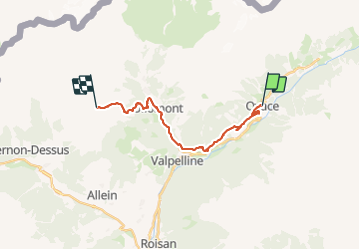
6Alta Via 1 : Oyace - Refuge Champillon (Version basse)

mpignon
User

Length
17.9 km

Max alt
2424 m

Uphill gradient
1648 m
Km-Effort
36 km

Min alt
1061 m

Downhill gradient
593 m
Boucle
No
Creation date :
2023-08-25 05:43:21.222
Updated on :
2023-08-28 16:09:55.977
7h23
Difficulty : Difficult

FREE GPS app for hiking
 SityTrail
IGN / Geographical institutes
SityTrail Plus
The world is yours!
About
Trail Walking of 17.9 km to be discovered at Aosta Valley, Unknown, Oyace. This trail is proposed by mpignon.
Positioning
Country:
Italy
Region :
Aosta Valley
Department/Province :
Unknown
Municipality :
Oyace
Location:
Unknown
Start:(Dec)
Start:(UTM)
374395 ; 5078733 (32T) N.
Comments