Trail Walking Viam - [Itinéraire] Le Tour du Lac de Viam - Photo

[Itinéraire] Le Tour du Lac de Viam

 houbart
houbart

User

© OpenStreetMap contributors
Length
Length
14.4 km
Max alt
Max alt
748 m
Uphill gradient
Uphill gradient
311 m
Km-Effort
Km-Effort  
18.5 km
Min alt
Min alt
651 m
Downhill gradient
Downhill gradient
307 m
Boucle
Boucle
Yes
Creation date :
2023-08-26 13:34:30.181
Updated on :
2023-08-26 13:41:03.141

(1 Reviews)

Walking
Walking
4h12
Difficulty : Difficult

Scan this QR Code to open this trail in the SityTrail application

FREE GPS app for hiking

Logo SityTrail SityTrail

IGN / Geographical institutes

Download SityTrail from the App Store Download SityTrail from Google Play

Logo SityTrail SityTrail World

The world is yours!

Download SityTrail from the App Store Download SityTrail from Google Play Download SityTrail on Huawei AppGallery

About

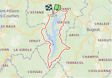
Trail Walking of 14.4 km to be discovered at New Aquitaine, Corrèze, Viam. This trail is proposed by houbart.

Description

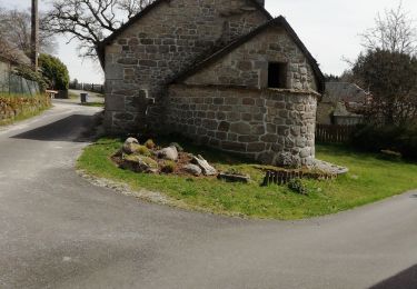
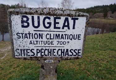
- Depuis le parking, descendre vers la terrasse direction la salle polyvalente. Le chemin commence sur la gauche et passe sur une digue. Remonter ensuite la route jusqu'à l'intersection avec la D979. - Prendre alors à droite vers Bugeat.
- Tourner à droite direction Sirieix. Suivre cette route jusqu'au village de Couignoux. Dans le village prendre à gauche et monter vers le Monteil. 100 m avant le hameau, bifurquer à droite. Poursuivre un long moment entre prés et bois sur la piste principale.
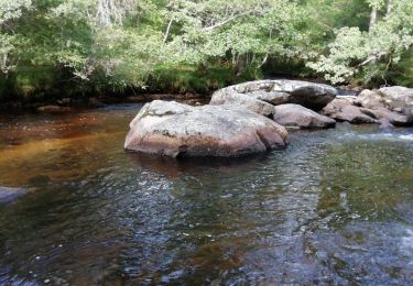
- Passer à droite de l?Etang de Salemagnières (aussi appelé Etang de Mouno) et remonter jusqu'à un large carrefour. Prendre alors à droite pour rejoindre le barrage. Traverser l'édifice et continuer la piste jusqu'à retrouver la route D160 à prendre à droite pour revenir à Viam

Elevation profile

Points of interest

Point of interest Saint-Hilaire-les-Courbes - Ouvrage: Barrage de Viam - Photo
houbart
SAINT-HILAIRE-LES-COURBES 

Positioning

Country:
France
Region :
New Aquitaine
Department/Province :
Corrèze
Municipality :
Viam
Location:
Unknown
Start:(UTM)
412998 ; 5051202 (31T) N.

Comments

Please log in to post a review or rate the element


Trails nearby

Trail Mountain bike Bugeat - Bugeat N° 34 + 37 - Photo
Mountain bike
Midego

Mountain bike

Medium
(1)
Bugeat, New Aquitaine, Corrèze, France
37 km | 47 km-effort
3h 0min
Yes
Trail Mountain bike Bugeat - Boucle au départ du Petit Luc via Gourdon - Photo
Mountain bike
louveteau19

Mountain bike

Difficult
(1)
Bugeat, New Aquitaine, Corrèze, France
25 km | 31 km-effort
2h 9min
Yes
Trail Running Lacelle - Jour 18 CAP Jeanot - Photo
Running
jeannat

Running

Very easy
Lacelle, New Aquitaine, Corrèze, France
33 km | 43 km-effort
3h 51min
No
Trail Running Lacelle - Jour 18 CAP Jeanot - Photo
Running
jeannat

Running

Very easy
Lacelle, New Aquitaine, Corrèze, France
33 km | 43 km-effort
3h 51min
No
Trail Walking L'Église-aux-Bois - Lacelle Treignac - Photo
Walking
Jamartrita

Walking

Easy
L'Église-aux-Bois, New Aquitaine, Corrèze, France
17.9 km | 23 km-effort
5h 58min
No
Trail Walking Viam - Fred BC Viam - Photo
Walking
arnoultjf

Walking

Medium
Viam, New Aquitaine, Corrèze, France
7.8 km | 10.1 km-effort
2h 18min
Yes
Trail Walking Bugeat - Fred Bugeat la vezere - Photo
Walking
arnoultjf

Walking

Medium
Bugeat, New Aquitaine, Corrèze, France
6.5 km | 8 km-effort
3h 21min
Yes
Trail Walking Bugeat - balade dans le bois de Chaleix  - Photo
Walking
viam19

Walking

Medium
Bugeat, New Aquitaine, Corrèze, France
6 km | 7.6 km-effort
2h 11min
Yes
Trail Walking Bugeat - Viam - Photo
Walking
frederic.farge

Walking

Very difficult
Bugeat, New Aquitaine, Corrèze, France
17 km | 22 km-effort
1h 6min
No


Close
My subscriptions