


Véloroute du vignoble

apa
User
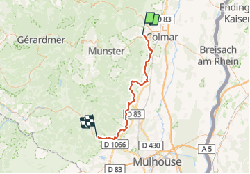

Length
55 km

Max alt
337 m

Uphill gradient
473 m
Km-Effort
61 km

Min alt
188 m

Downhill gradient
373 m
Boucle
No
Creation date :
2023-08-27 07:26:13.519
Updated on :
2023-08-27 11:39:43.229
3h31
Difficulty : Medium

FREE GPS app for hiking
 SityTrail
IGN / Geographical institutes
SityTrail Plus
The world is yours!
About
Trail Road bike of 55 km to be discovered at Grand Est, Haut-Rhin, Turckheim. This trail is proposed by apa.
Description
magnifique entre Vignes
Photos


Positioning
Country:
France
Region :
Grand Est
Department/Province :
Haut-Rhin
Municipality :
Turckheim
Location:
Unknown
Start:(Dec)
Start:(UTM)
372036 ; 5326902 (32U) N.
Comments