


8.6 km | 14.1 km-effort

User


FREE GPS app for hiking
 SityTrail
IGN / Geographical institutes
SityTrail World
The world is yours!
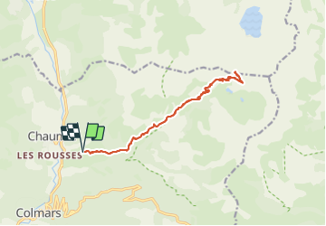
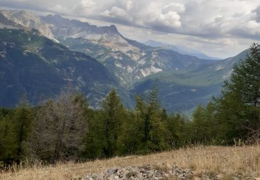
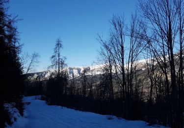
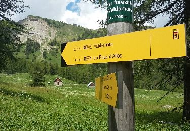
Trail Walking of 17.1 km to be discovered at Provence-Alpes-Côte d'Azur, Alpes-de-Haute-Provence, Colmars. This trail is proposed by Marchopier.
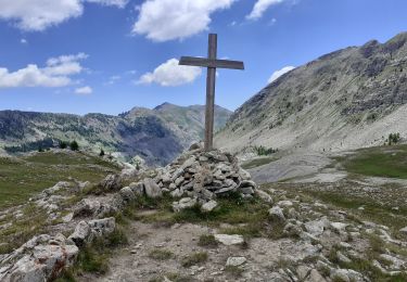
Départ de Clignon Haut, vers le Col de l'Encombrette par le GR de pays Tour du Haut Verdon
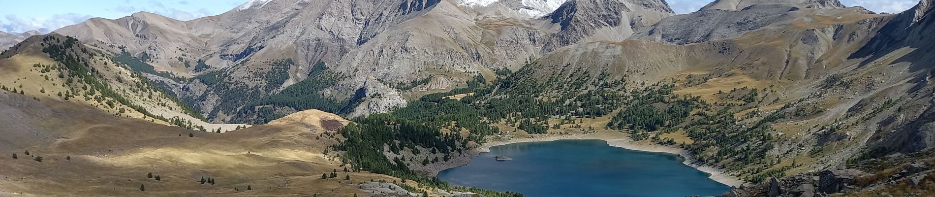
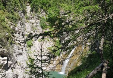
Paysages magnifiques notamment le long du Rio, accompagné par les chamois et bouquetins profitant de l'heure matinale, puis les marmottes
Lacs de l'Encombrette et panorama exceptionnel sur le lac d'Allos et le Mont Pelat enneigé depuis le Col, avec un petit vent glacial qui se lève
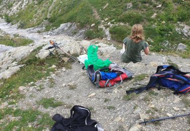
Retour par le même sentier, bien plus facile à la descente,finalement
 "
data-pinterest-text="Pin it"
data-tweet-text="share on twitter"
data-facebook-share-url="https://www.sitytrail.com/en/trails/3788194-colmars--col-de-lxencombrette-ar-clignon-haut/?photo=1#lg=1&slide=1"
data-twitter-share-url="https://www.sitytrail.com/en/trails/3788194-colmars--col-de-lxencombrette-ar-clignon-haut/?photo=1#lg=1&slide=1"
data-googleplus-share-url="https://www.sitytrail.com/en/trails/3788194-colmars--col-de-lxencombrette-ar-clignon-haut/?photo=1#lg=1&slide=1"
data-pinterest-share-url="https://www.sitytrail.com/en/trails/3788194-colmars--col-de-lxencombrette-ar-clignon-haut/?photo=1#lg=1&slide=1">
"
data-pinterest-text="Pin it"
data-tweet-text="share on twitter"
data-facebook-share-url="https://www.sitytrail.com/en/trails/3788194-colmars--col-de-lxencombrette-ar-clignon-haut/?photo=1#lg=1&slide=1"
data-twitter-share-url="https://www.sitytrail.com/en/trails/3788194-colmars--col-de-lxencombrette-ar-clignon-haut/?photo=1#lg=1&slide=1"
data-googleplus-share-url="https://www.sitytrail.com/en/trails/3788194-colmars--col-de-lxencombrette-ar-clignon-haut/?photo=1#lg=1&slide=1"
data-pinterest-share-url="https://www.sitytrail.com/en/trails/3788194-colmars--col-de-lxencombrette-ar-clignon-haut/?photo=1#lg=1&slide=1">
 "
data-pinterest-text="Pin it"
data-tweet-text="share on twitter"
data-facebook-share-url="https://www.sitytrail.com/en/trails/3788194-colmars--col-de-lxencombrette-ar-clignon-haut/?photo=2#lg=1&slide=2"
data-twitter-share-url="https://www.sitytrail.com/en/trails/3788194-colmars--col-de-lxencombrette-ar-clignon-haut/?photo=2#lg=1&slide=2"
data-googleplus-share-url="https://www.sitytrail.com/en/trails/3788194-colmars--col-de-lxencombrette-ar-clignon-haut/?photo=2#lg=1&slide=2"
data-pinterest-share-url="https://www.sitytrail.com/en/trails/3788194-colmars--col-de-lxencombrette-ar-clignon-haut/?photo=2#lg=1&slide=2">
"
data-pinterest-text="Pin it"
data-tweet-text="share on twitter"
data-facebook-share-url="https://www.sitytrail.com/en/trails/3788194-colmars--col-de-lxencombrette-ar-clignon-haut/?photo=2#lg=1&slide=2"
data-twitter-share-url="https://www.sitytrail.com/en/trails/3788194-colmars--col-de-lxencombrette-ar-clignon-haut/?photo=2#lg=1&slide=2"
data-googleplus-share-url="https://www.sitytrail.com/en/trails/3788194-colmars--col-de-lxencombrette-ar-clignon-haut/?photo=2#lg=1&slide=2"
data-pinterest-share-url="https://www.sitytrail.com/en/trails/3788194-colmars--col-de-lxencombrette-ar-clignon-haut/?photo=2#lg=1&slide=2">
 "
data-pinterest-text="Pin it"
data-tweet-text="share on twitter"
data-facebook-share-url="https://www.sitytrail.com/en/trails/3788194-colmars--col-de-lxencombrette-ar-clignon-haut/?photo=3#lg=1&slide=3"
data-twitter-share-url="https://www.sitytrail.com/en/trails/3788194-colmars--col-de-lxencombrette-ar-clignon-haut/?photo=3#lg=1&slide=3"
data-googleplus-share-url="https://www.sitytrail.com/en/trails/3788194-colmars--col-de-lxencombrette-ar-clignon-haut/?photo=3#lg=1&slide=3"
data-pinterest-share-url="https://www.sitytrail.com/en/trails/3788194-colmars--col-de-lxencombrette-ar-clignon-haut/?photo=3#lg=1&slide=3">
"
data-pinterest-text="Pin it"
data-tweet-text="share on twitter"
data-facebook-share-url="https://www.sitytrail.com/en/trails/3788194-colmars--col-de-lxencombrette-ar-clignon-haut/?photo=3#lg=1&slide=3"
data-twitter-share-url="https://www.sitytrail.com/en/trails/3788194-colmars--col-de-lxencombrette-ar-clignon-haut/?photo=3#lg=1&slide=3"
data-googleplus-share-url="https://www.sitytrail.com/en/trails/3788194-colmars--col-de-lxencombrette-ar-clignon-haut/?photo=3#lg=1&slide=3"
data-pinterest-share-url="https://www.sitytrail.com/en/trails/3788194-colmars--col-de-lxencombrette-ar-clignon-haut/?photo=3#lg=1&slide=3">
 "
data-pinterest-text="Pin it"
data-tweet-text="share on twitter"
data-facebook-share-url="https://www.sitytrail.com/en/trails/3788194-colmars--col-de-lxencombrette-ar-clignon-haut/?photo=4#lg=1&slide=4"
data-twitter-share-url="https://www.sitytrail.com/en/trails/3788194-colmars--col-de-lxencombrette-ar-clignon-haut/?photo=4#lg=1&slide=4"
data-googleplus-share-url="https://www.sitytrail.com/en/trails/3788194-colmars--col-de-lxencombrette-ar-clignon-haut/?photo=4#lg=1&slide=4"
data-pinterest-share-url="https://www.sitytrail.com/en/trails/3788194-colmars--col-de-lxencombrette-ar-clignon-haut/?photo=4#lg=1&slide=4">
"
data-pinterest-text="Pin it"
data-tweet-text="share on twitter"
data-facebook-share-url="https://www.sitytrail.com/en/trails/3788194-colmars--col-de-lxencombrette-ar-clignon-haut/?photo=4#lg=1&slide=4"
data-twitter-share-url="https://www.sitytrail.com/en/trails/3788194-colmars--col-de-lxencombrette-ar-clignon-haut/?photo=4#lg=1&slide=4"
data-googleplus-share-url="https://www.sitytrail.com/en/trails/3788194-colmars--col-de-lxencombrette-ar-clignon-haut/?photo=4#lg=1&slide=4"
data-pinterest-share-url="https://www.sitytrail.com/en/trails/3788194-colmars--col-de-lxencombrette-ar-clignon-haut/?photo=4#lg=1&slide=4">

Walking
Walking
Walking
Walking
Walking
Walking

Walking
Snowshoes
Walking