


rando avec Cam s 1

jpipacific
User
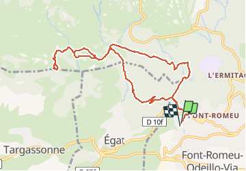

Length
11.9 km

Max alt
2002 m

Uphill gradient
380 m
Km-Effort
17 km

Min alt
1706 m

Downhill gradient
392 m
Boucle
Yes
Creation date :
2017-04-01 00:00:00.0
Updated on :
2017-04-01 00:00:00.0
5h31
Difficulty : Medium

FREE GPS app for hiking
 SityTrail
IGN / Geographical institutes
SityTrail Plus
The world is yours!
About
Trail Snowshoes of 11.9 km to be discovered at Occitania, Pyrénées-Orientales, Font-Romeu-Odeillo-Via. This trail is proposed by jpipacific.
Description
vers pic des maures
Positioning
Country:
France
Region :
Occitania
Department/Province :
Pyrénées-Orientales
Municipality :
Font-Romeu-Odeillo-Via
Location:
Unknown
Start:(Dec)
Start:(UTM)
420613 ; 4706156 (31T) N.
Comments