


LAC DE LA LAUCH

surceneux
User
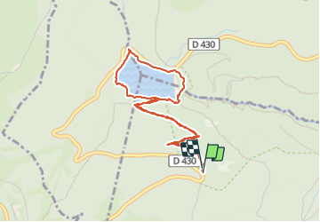

Length
4.2 km

Max alt
1112 m

Uphill gradient
183 m
Km-Effort
6.7 km

Min alt
928 m

Downhill gradient
189 m
Boucle
Yes
Creation date :
2023-09-04 13:16:57.421
Updated on :
2023-09-04 15:49:03.898
1h45
Difficulty : Easy

FREE GPS app for hiking
 SityTrail
IGN / Geographical institutes
SityTrail Plus
The world is yours!
About
Trail Walking of 4.2 km to be discovered at Grand Est, Haut-Rhin, Lautenbachzell. This trail is proposed by surceneux.
Description
TOUR DU LAC DEPART RECT JAUNE
AR
Positioning
Country:
France
Region :
Grand Est
Department/Province :
Haut-Rhin
Municipality :
Lautenbachzell
Location:
Unknown
Start:(Dec)
Start:(UTM)
354225 ; 5310304 (32T) N.
Comments