


le sambuis

bymarc26
User
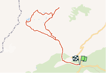

Length
11.5 km

Max alt
2713 m

Uphill gradient
923 m
Km-Effort
24 km

Min alt
1912 m

Downhill gradient
923 m
Boucle
Yes
Creation date :
2023-09-03 06:56:02.248
Updated on :
2023-09-04 18:07:33.641
4h54
Difficulty : Very difficult

FREE GPS app for hiking
 SityTrail
IGN / Geographical institutes
SityTrail Plus
The world is yours!
About
Trail Walking of 11.5 km to be discovered at Auvergne-Rhône-Alpes, Savoy, Saint-Colomban-des-Villards. This trail is proposed by bymarc26.
Photos


Positioning
Country:
France
Region :
Auvergne-Rhône-Alpes
Department/Province :
Savoy
Municipality :
Saint-Colomban-des-Villards
Location:
Unknown
Start:(Dec)
Start:(UTM)
278290 ; 5013429 (32T) N.
Comments