


Bruebach 12 km

pmauvieux
User
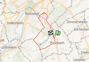

Length
12.2 km

Max alt
357 m

Uphill gradient
243 m
Km-Effort
15.4 km

Min alt
290 m

Downhill gradient
243 m
Boucle
Yes
Creation date :
2023-09-05 14:15:52.861
Updated on :
2023-09-05 20:26:53.615
2h36
Difficulty : Medium

FREE GPS app for hiking
 SityTrail
IGN / Geographical institutes
SityTrail Plus
The world is yours!
About
Trail Walking of 12.2 km to be discovered at Grand Est, Haut-Rhin, Bruebach. This trail is proposed by pmauvieux.
Positioning
Country:
France
Region :
Grand Est
Department/Province :
Haut-Rhin
Municipality :
Bruebach
Location:
Unknown
Start:(Dec)
Start:(UTM)
376731 ; 5284776 (32T) N.
Comments