


Port Argelès - Collioure

cron
User
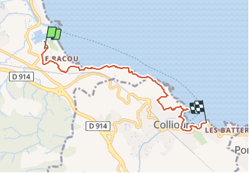

Length
6.8 km

Max alt
55 m

Uphill gradient
148 m
Km-Effort
8.7 km

Min alt
0 m

Downhill gradient
128 m
Boucle
No
Creation date :
2023-09-06 19:26:50.236
Updated on :
2023-09-06 19:28:39.735
1h58
Difficulty : Medium

FREE GPS app for hiking
 SityTrail
IGN / Geographical institutes
SityTrail Plus
The world is yours!
About
Trail Walking of 6.8 km to be discovered at Occitania, Pyrénées-Orientales, Argelès-sur-Mer. This trail is proposed by cron.
Description
attention : kilométrage indiquant uniquement la distance de l'aller. Penser à multiplier par deux pour un A/R.
Positioning
Country:
France
Region :
Occitania
Department/Province :
Pyrénées-Orientales
Municipality :
Argelès-sur-Mer
Location:
Unknown
Start:(Dec)
Start:(UTM)
504193 ; 4709617 (31T) N.
Comments