


les 2 cols

duchaine.nicolas
User
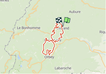

Length
28 km

Max alt
681 m

Uphill gradient
892 m
Km-Effort
39 km

Min alt
417 m

Downhill gradient
893 m
Boucle
Yes
Creation date :
2023-09-09 09:22:27.418
Updated on :
2023-09-09 12:02:41.995
2h39
Difficulty : Easy
2h39
Difficulty : Easy

FREE GPS app for hiking
 SityTrail
IGN / Geographical institutes
SityTrail Plus
The world is yours!
About
Trail Mountain bike of 28 km to be discovered at Grand Est, Haut-Rhin, Fréland. This trail is proposed by duchaine.nicolas.
Positioning
Country:
France
Region :
Grand Est
Department/Province :
Haut-Rhin
Municipality :
Fréland
Location:
Unknown
Start:(Dec)
Start:(UTM)
365796 ; 5337167 (32U) N.
Comments