Trail Road bike Chanay - Le Grand Colombier par Anglefort - Photo

Le Grand Colombier par Anglefort

© OpenStreetMap contributors
Length
Length
61 km
Max alt
Max alt
1499 m
Uphill gradient
Uphill gradient
1788 m
Km-Effort
Km-Effort  
85 km
Min alt
Min alt
286 m
Downhill gradient
Downhill gradient
1790 m
Boucle
Boucle
Yes
Creation date :
2023-09-14 07:02:21.633
Updated on :
2023-09-14 11:02:02.942

(0 Reviews)

Road bike
Road bike
3h38
Difficulty : Difficult

Scan this QR Code to open this trail in the SityTrail application

FREE GPS app for hiking

Logo SityTrail SityTrail

IGN / Geographical institutes

Download SityTrail from the App Store Download SityTrail from Google Play

Logo SityTrail SityTrail World

The world is yours!

Download SityTrail from the App Store Download SityTrail from Google Play Download SityTrail on Huawei AppGallery

About

Trail Road bike of 61 km to be discovered at Auvergne-Rhône-Alpes, Ain, Chanay. This trail is proposed by PhilippeC54.

Description

retour par col de Richemond

Elevation profile

Positioning

Country:
France
Region :
Auvergne-Rhône-Alpes
Department/Province :
Ain
Municipality :
Chanay
Location:
Unknown
Start:(UTM)
715450 ; 5098367 (31T) N.

Trails nearby

Trail Walking Chanay - Le Colombier  - Photo
Walking
Arvierie56@Gmail.com

Walking

Medium
Chanay, Auvergne-Rhône-Alpes, Ain, France
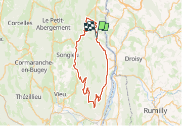
27 km | 40 km-effort
6h 53min
Yes
Trail Walking Challonges - CHALLONGES - Photo
Walking
COMAN

Walking

Easy
Challonges, Auvergne-Rhône-Alpes, Upper Savoy, France
9.3 km | 13 km-effort
2h 46min
Yes
Trail Walking Bassy - bassy - Photo
Walking
jibe01

Walking

Easy
Bassy, Auvergne-Rhône-Alpes, Upper Savoy, France
7 km | 9.3 km-effort
2h 7min
Yes
Trail Winter sports Haut Valromey - pre carré - Photo
Winter sports
jibe01

Winter sports

Medium
Haut Valromey, Auvergne-Rhône-Alpes, Ain, France
9.6 km | 13.5 km-effort
3h 39min
Yes
Trail Other activity Corbonod - puthier - Photo
Other activity
jibe01

Other activity

Very easy
Corbonod, Auvergne-Rhône-Alpes, Ain, France
4.6 km | 7.6 km-effort
1h 0min
Yes
Trail Running Seyssel - vierge curty cologny seydsel - Photo
Running
kalaene

Running

Medium
Seyssel, Auvergne-Rhône-Alpes, Upper Savoy, France
12.8 km | 17.6 km-effort
1h 28min
Yes
Trail Running Seyssel - base nautique - Photo
Running
kalaene

Running

Easy
Seyssel, Auvergne-Rhône-Alpes, Upper Savoy, France
13 km | 14.7 km-effort
1h 16min
Yes
Trail Running Seyssel - mont des princes par vens - Photo
Running
kalaene

Running

Difficult
Seyssel, Auvergne-Rhône-Alpes, Upper Savoy, France
15.6 km | 26 km-effort
2h 17min
Yes
Trail Running Seyssel - cascade eilloux - Photo
Running
kalaene

Running

Medium
Seyssel, Auvergne-Rhône-Alpes, Upper Savoy, France
14.5 km | 18 km-effort
1h 39min
Yes


Close
My subscriptions