


Archives_Mantrailing_Savignac les Eglises

Amicale Canine du Boulou
Recherche Utilitaire
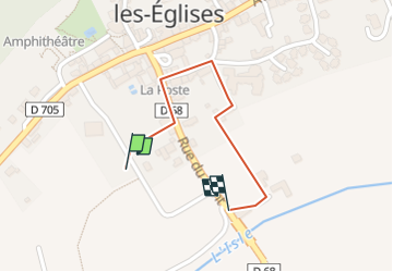

Length
584 m

Max alt
116 m

Uphill gradient
4 m
Km-Effort
640 m

Min alt
109 m

Downhill gradient
5 m
Boucle
Yes
Creation date :
2023-09-17 20:24:58.254
Updated on :
2024-10-21 08:44:18.275
8m
Difficulty : Easy

FREE GPS app for hiking
 SityTrail
IGN / Geographical institutes
SityTrail Plus
The world is yours!
About
Trail Walking of 584 m to be discovered at New Aquitaine, Dordogne, Savignac-les-Églises. This trail is proposed by Amicale Canine du Boulou.
Positioning
Country:
France
Region :
New Aquitaine
Department/Province :
Dordogne
Municipality :
Savignac-les-Églises
Location:
Unknown
Start:(Dec)
Start:(UTM)
336366 ; 5015247 (31T) N.
Comments