


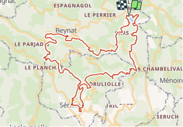
SityTrail - 3810281 - or-vtt-30km

Gpoujade
User

Length
29 km

Max alt
552 m

Uphill gradient
743 m
Km-Effort
39 km

Min alt
236 m

Downhill gradient
740 m
Boucle
Yes
Creation date :
2023-09-18 09:31:51.0
Updated on :
2024-02-15 09:59:13.325
2h40
Difficulty : Difficult

FREE GPS app for hiking
 SityTrail
IGN / Geographical institutes
SityTrail Plus
The world is yours!
About
Trail Mountain bike of 29 km to be discovered at New Aquitaine, Corrèze, Beynat. This trail is proposed by Gpoujade.
Description
Rando octobre Rose 2023 : Boucle au départ du lac de miel à Beynat vers Sérilhac , ancienne voie du Tacot, Beynat
Positioning
Country:
France
Region :
New Aquitaine
Department/Province :
Corrèze
Municipality :
Beynat
Location:
Unknown
Start:(Dec)
Start:(UTM)
402855 ; 4998291 (31T) N.
Comments