


Montcenis/ gran scala

laurentnecca
User
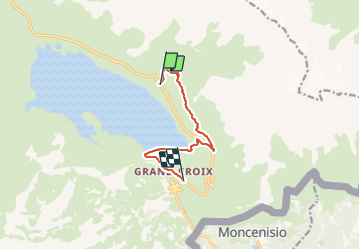

Length
8 km

Max alt
2286 m

Uphill gradient
212 m
Km-Effort
11.5 km

Min alt
1869 m

Downhill gradient
428 m
Boucle
No
Creation date :
2023-09-19 07:16:30.31
Updated on :
2023-09-19 15:17:45.122
3h00
Difficulty : Medium

FREE GPS app for hiking
 SityTrail
IGN / Geographical institutes
SityTrail Plus
The world is yours!
About
Trail Walking of 8 km to be discovered at Auvergne-Rhône-Alpes, Savoy, Val-Cenis. This trail is proposed by laurentnecca.
Positioning
Country:
France
Region :
Auvergne-Rhône-Alpes
Department/Province :
Savoy
Municipality :
Val-Cenis
Location:
Lanslebourg-Mont-Cenis
Start:(Dec)
Start:(UTM)
339178 ; 5011766 (32T) N.
Comments