


herlisheim

claudel
User
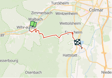

Length
15.2 km

Max alt
754 m

Uphill gradient
536 m
Km-Effort
23 km

Min alt
188 m

Downhill gradient
652 m
Boucle
No
Creation date :
2023-09-20 07:49:00.696
Updated on :
2023-09-20 13:27:38.956
5h37
Difficulty : Very difficult

FREE GPS app for hiking
 SityTrail
IGN / Geographical institutes
SityTrail Plus
The world is yours!
About
Trail Walking of 15.2 km to be discovered at Grand Est, Haut-Rhin, Wihr-au-Val. This trail is proposed by claudel.
Positioning
Country:
France
Region :
Grand Est
Department/Province :
Haut-Rhin
Municipality :
Wihr-au-Val
Location:
Unknown
Start:(Dec)
Start:(UTM)
366577 ; 5323003 (32U) N.
Comments