


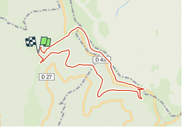
Départ ferme auberge du Schafert - direction Hundskopf - Klein Hahnenbrunnen et Chemin du Hell

patrickbeyrath
User

Length
8.9 km

Max alt
1223 m

Uphill gradient
288 m
Km-Effort
12.7 km

Min alt
954 m

Downhill gradient
290 m
Boucle
Yes
Creation date :
2023-09-21 07:04:28.652
Updated on :
2024-10-18 05:49:05.305
2h53
Difficulty : Difficult

FREE GPS app for hiking
 SityTrail
IGN / Geographical institutes
SityTrail Plus
The world is yours!
About
Trail Walking of 8.9 km to be discovered at Grand Est, Haut-Rhin, Kruth. This trail is proposed by patrickbeyrath.
Positioning
Country:
France
Region :
Grand Est
Department/Province :
Haut-Rhin
Municipality :
Kruth
Location:
Unknown
Start:(Dec)
Start:(UTM)
349221 ; 5314020 (32T) N.
Comments