Trail Horseback riding Germond-Rouvre - Rando de l'Autize - Photo
 Dom4i
Dom4i

User

© OpenStreetMap contributors
Length
Length
27 km
Max alt
Max alt
121 m
Uphill gradient
Uphill gradient
369 m
Km-Effort
Km-Effort  
32 km
Min alt
Min alt
30 m
Downhill gradient
Downhill gradient
367 m
Boucle
Boucle
Yes
Creation date :
2023-09-23 07:33:19.341
Updated on :
2023-10-03 09:43:45.487

(0 Reviews)

Horseback riding
Horseback riding
4h09
Difficulty : Difficult

Scan this QR Code to open this trail in the SityTrail application

FREE GPS app for hiking

Logo SityTrail SityTrail

IGN / Geographical institutes

Download SityTrail from the App Store Download SityTrail from Google Play

Logo SityTrail SityTrail World

The world is yours!

Download SityTrail from the App Store Download SityTrail from Google Play Download SityTrail on Huawei AppGallery

About

Trail Horseback riding of 27 km to be discovered at New Aquitaine, Deux-Sèvres, Germond-Rouvre. This trail is proposed by Dom4i.

Elevation profile

Positioning

Country:
France
Region :
New Aquitaine
Department/Province :
Deux-Sèvres
Municipality :
Germond-Rouvre
Location:
Unknown
Start:(UTM)
697951 ; 5151066 (30T) N.

Trails nearby

Trail Walking Germond-Rouvre - 2020-09-19  - Photo
Walking
cagouille79

Walking

Medium
Germond-Rouvre, New Aquitaine, Deux-Sèvres, France
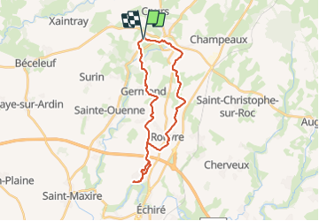
12.9 km | 16.2 km-effort
2h 59min
Yes
Trail Walking Champdeniers - Champeaux - Photo
Walking
olaze

Walking

Easy
Champdeniers, New Aquitaine, Deux-Sèvres, France
8.1 km | 9.8 km-effort
2h 8min
Yes
Trail Walking Sainte-Ouenne - St Ouenne - Photo
Walking
olaze

Walking

Medium
Sainte-Ouenne, New Aquitaine, Deux-Sèvres, France
10.2 km | 12.3 km-effort
2h 40min
Yes
Trail Walking Surin - Les Terres Rouges de la Véquière - Photo
Walking
tracegps

Walking

Medium
Surin, New Aquitaine, Deux-Sèvres, France
13.6 km | 16.1 km-effort
3h 30min
Yes
Trail Walking Surin - Les Terres Rouges de la Véquière - Photo
Walking
dan79

Walking

Easy
Surin, New Aquitaine, Deux-Sèvres, France
13.6 km | 16.1 km-effort
3h 29min
Yes
Trail Walking Sainte-Ouenne - Saint Ouenne (@) - Photo
Walking
olaze

Walking

Easy
Sainte-Ouenne, New Aquitaine, Deux-Sèvres, France
8.6 km | 10.5 km-effort
2h 30min
Yes
Trail Mountain bike Surin - 2012-09-23 Vallée de l'Egray (raccourcie) - Photo
Mountain bike
cagouille79

Mountain bike

Medium
Surin, New Aquitaine, Deux-Sèvres, France
16.6 km | 20 km-effort
1h 28min
Yes
Trail Bicycle tourism Champdeniers - Vélofrancette - Tronçon 5 - Photo
Bicycle tourism
ves

Bicycle tourism

Very easy
Champdeniers, New Aquitaine, Deux-Sèvres, France
111 km | 120 km-effort
Unknown
No
Trail Horseback riding Champdeniers - Fusion Autize 1 et 2 - Photo
Horseback riding
Dom4i

Horseback riding

Very difficult
Champdeniers, New Aquitaine, Deux-Sèvres, France
42 km | 49 km-effort
6h 26min
Yes


Close
My subscriptions