


Montée au refuge Gnifeti

mpignon
User
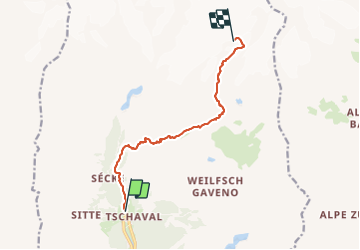

Length
9.4 km

Max alt
3624 m

Uphill gradient
1805 m
Km-Effort
28 km

Min alt
1817 m

Downhill gradient
21 m
Boucle
No
Creation date :
2023-09-24 06:56:00.585
Updated on :
2023-09-26 12:33:52.707
6h00
Difficulty : Very difficult

FREE GPS app for hiking
 SityTrail
IGN / Geographical institutes
SityTrail Plus
The world is yours!
About
Trail Walking of 9.4 km to be discovered at Aosta Valley, Unknown, Gressoney-La-Trinité. This trail is proposed by mpignon.
Positioning
Country:
Italy
Region :
Aosta Valley
Department/Province :
Unknown
Municipality :
Gressoney-La-Trinité
Location:
Unknown
Start:(Dec)
Start:(UTM)
407840 ; 5079044 (32T) N.
Comments