


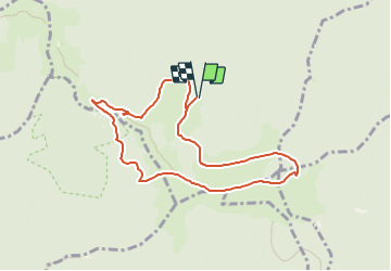
Parking FA du Giang - Vers le GR 532 - Sattel - Rossberg - ThannerHubel et retour

patrickbeyrath
User

Length
7.9 km

Max alt
1162 m

Uphill gradient
325 m
Km-Effort
12.3 km

Min alt
1003 m

Downhill gradient
324 m
Boucle
Yes
Creation date :
2023-09-28 05:43:41.965
Updated on :
2023-09-28 06:06:28.782
2h47
Difficulty : Difficult

FREE GPS app for hiking
 SityTrail
IGN / Geographical institutes
SityTrail Plus
The world is yours!
About
Trail Walking of 7.9 km to be discovered at Grand Est, Haut-Rhin, Moosch. This trail is proposed by patrickbeyrath.
Positioning
Country:
France
Region :
Grand Est
Department/Province :
Haut-Rhin
Municipality :
Moosch
Location:
Unknown
Start:(Dec)
Start:(UTM)
351299 ; 5299565 (32T) N.
Comments