


col sambuis

Liebeaux
User
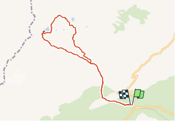

Length
9.6 km

Max alt
2520 m

Uphill gradient
642 m
Km-Effort
18.2 km

Min alt
1912 m

Downhill gradient
639 m
Boucle
Yes
Creation date :
2023-09-28 06:59:41.427
Updated on :
2023-09-28 15:35:22.699
6h52
Difficulty : Difficult

FREE GPS app for hiking
 SityTrail
IGN / Geographical institutes
SityTrail Plus
The world is yours!
About
Trail Walking of 9.6 km to be discovered at Auvergne-Rhône-Alpes, Savoy, Saint-Colomban-des-Villards. This trail is proposed by Liebeaux.
Positioning
Country:
France
Region :
Auvergne-Rhône-Alpes
Department/Province :
Savoy
Municipality :
Saint-Colomban-des-Villards
Location:
Unknown
Start:(Dec)
Start:(UTM)
278328 ; 5013451 (32T) N.
Comments