


Bauges Péclot

c.gourme
User
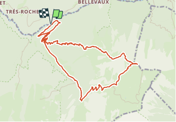

Length
13.3 km

Max alt
2174 m

Uphill gradient
1354 m
Km-Effort
31 km

Min alt
867 m

Downhill gradient
1365 m
Boucle
Yes
Creation date :
2023-09-28 06:40:04.0
Updated on :
2023-09-28 15:39:58.373
7h02
Difficulty : Difficult

FREE GPS app for hiking
 SityTrail
IGN / Geographical institutes
SityTrail Plus
The world is yours!
About
Trail Walking of 13.3 km to be discovered at Auvergne-Rhône-Alpes, Savoy, École. This trail is proposed by c.gourme.
Description
On peut aussi faire le sommet de l’Armenaz, rajouter 100 m.
La montée au début vers le Peclot est raide et vertigineuse : randos, à faire uniquement par beau temps et ton sec.
Positioning
Country:
France
Region :
Auvergne-Rhône-Alpes
Department/Province :
Savoy
Municipality :
École
Location:
Unknown
Start:(Dec)
Start:(UTM)
282152 ; 5057731 (32T) N.
Comments