


13 Ste Victoire Col des Portes La Citadelle La Sinne

ARPF
User
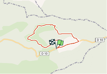

Length
7.2 km

Max alt
711 m

Uphill gradient
191 m
Km-Effort
9.8 km

Min alt
544 m

Downhill gradient
192 m
Boucle
Yes
Creation date :
2016-11-14 00:00:00.0
Updated on :
2016-11-14 00:00:00.0
2h04
Difficulty : Very easy

FREE GPS app for hiking
 SityTrail
IGN / Geographical institutes
SityTrail Plus
The world is yours!
About
Trail Walking of 7.2 km to be discovered at Provence-Alpes-Côte d'Azur, Bouches-du-Rhône, Vauvenargues. This trail is proposed by ARPF.
Description
P1 T1 demie journée
Positioning
Country:
France
Region :
Provence-Alpes-Côte d'Azur
Department/Province :
Bouches-du-Rhône
Municipality :
Vauvenargues
Location:
Unknown
Start:(Dec)
Start:(UTM)
715991 ; 4825444 (31T) N.
Comments