


DORDOGNE / SAINT MESMIN: L' AUVEZERE

djeepee74
User
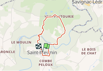

Length
3.2 km

Max alt
305 m

Uphill gradient
161 m
Km-Effort
5.3 km

Min alt
212 m

Downhill gradient
162 m
Boucle
Yes
Creation date :
2023-10-04 09:01:27.976
Updated on :
2023-10-16 18:39:41.182
1h12
Difficulty : Easy

FREE GPS app for hiking
 SityTrail
IGN / Geographical institutes
SityTrail Plus
The world is yours!
About
Trail Walking of 3.2 km to be discovered at New Aquitaine, Dordogne, Saint-Mesmin. This trail is proposed by djeepee74.
Description
BOUCLE... live du 20231004
Photos


Positioning
Country:
France
Region :
New Aquitaine
Department/Province :
Dordogne
Municipality :
Saint-Mesmin
Location:
Unknown
Start:(Dec)
Start:(UTM)
359431 ; 5023697 (31T) N.
Comments