


Rando Magné-Coulon

dudu79
User
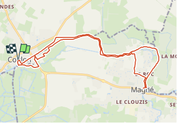

Length
11.6 km

Max alt
12 m

Uphill gradient
76 m
Km-Effort
12.6 km

Min alt
0 m

Downhill gradient
76 m
Boucle
Yes
Creation date :
2023-10-05 09:58:26.625
Updated on :
2023-10-05 10:15:55.588
2h51
Difficulty : Difficult

FREE GPS app for hiking
 SityTrail
IGN / Geographical institutes
SityTrail Plus
The world is yours!
About
Trail Walking of 11.6 km to be discovered at New Aquitaine, Deux-Sèvres, Coulon. This trail is proposed by dudu79.
Positioning
Country:
France
Region :
New Aquitaine
Department/Province :
Deux-Sèvres
Municipality :
Coulon
Location:
Unknown
Start:(Dec)
Start:(UTM)
685794 ; 5132651 (30T) N.
Comments