


col du schirm

heurtinpatrick
User
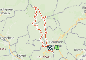

Length
16.9 km

Max alt
1186 m

Uphill gradient
713 m
Km-Effort
26 km

Min alt
598 m

Downhill gradient
713 m
Boucle
Yes
Creation date :
2023-10-05 07:27:48.466
Updated on :
2023-10-05 14:38:18.663
4h42
Difficulty : Medium

FREE GPS app for hiking
 SityTrail
IGN / Geographical institutes
SityTrail Plus
The world is yours!
About
Trail Walking of 16.9 km to be discovered at Grand Est, Haut-Rhin, Bourbach-le-Haut. This trail is proposed by heurtinpatrick.
Photos


Positioning
Country:
France
Region :
Grand Est
Department/Province :
Haut-Rhin
Municipality :
Bourbach-le-Haut
Location:
Unknown
Start:(Dec)
Start:(UTM)
352092 ; 5294573 (32T) N.
Comments