


route des vignes

duchaine.nicolas
User
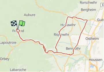

Length
44 km

Max alt
497 m

Uphill gradient
679 m
Km-Effort
53 km

Min alt
178 m

Downhill gradient
685 m
Boucle
Yes
Creation date :
2023-10-07 13:37:18.103
Updated on :
2023-10-07 16:19:48.837
2h42
Difficulty : Easy
2h42
Difficulty : Easy

FREE GPS app for hiking
 SityTrail
IGN / Geographical institutes
SityTrail Plus
The world is yours!
About
Trail Hybrid bike of 44 km to be discovered at Grand Est, Haut-Rhin, Fréland. This trail is proposed by duchaine.nicolas.
Positioning
Country:
France
Region :
Grand Est
Department/Province :
Haut-Rhin
Municipality :
Fréland
Location:
Unknown
Start:(Dec)
Start:(UTM)
365797 ; 5337175 (32U) N.
Comments