Bramans/ refuge bramanette / refuge Lo Tsamou

laurentnecca
User
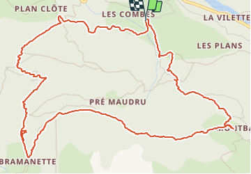

Length
8.4 km

Max alt
2159 m

Uphill gradient
570 m
Km-Effort
16 km

Min alt
1631 m

Downhill gradient
567 m
Boucle
Yes
Creation date :
2023-10-12 08:12:56.28
Updated on :
2023-10-12 12:42:57.405
3h46
Difficulty : Medium

FREE GPS app for hiking
 SityTrail
IGN / Geographical institutes
SityTrail Plus
The world is yours!
About
Trail Walking of 8.4 km to be discovered at Auvergne-Rhône-Alpes, Savoy, Val-Cenis. This trail is proposed by laurentnecca.
Positioning
Country:
France
Region :
Auvergne-Rhône-Alpes
Department/Province :
Savoy
Municipality :
Val-Cenis
Location:
Bramans
Start:(Dec)
Start:(UTM)
327596 ; 5009318 (32T) N.
Comments