


20231016 Blaye citadelle

Jeanclaudebic
User
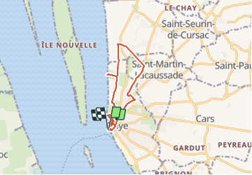

Length
11.7 km

Max alt
31 m

Uphill gradient
112 m
Km-Effort
13.2 km

Min alt
-3 m

Downhill gradient
111 m
Boucle
Yes
Creation date :
2023-10-16 06:00:22.88
Updated on :
2023-10-16 10:20:07.722
3h39
Difficulty : Difficult

FREE GPS app for hiking
 SityTrail
IGN / Geographical institutes
SityTrail Plus
The world is yours!
About
Trail Walking of 11.7 km to be discovered at New Aquitaine, Gironde, Blaye. This trail is proposed by Jeanclaudebic.
Positioning
Country:
France
Region :
New Aquitaine
Department/Province :
Gironde
Municipality :
Blaye
Location:
Unknown
Start:(Dec)
Start:(UTM)
683431 ; 4999588 (30T) N.
Comments