


20231017 St Émilion

Jeanclaudebic
User
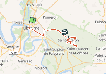

Length
20 km

Max alt
106 m

Uphill gradient
232 m
Km-Effort
23 km

Min alt
5 m

Downhill gradient
162 m
Boucle
No
Creation date :
2023-10-17 10:56:27.103
Updated on :
2023-10-17 15:57:44.272
4h25
Difficulty : Very difficult

FREE GPS app for hiking
 SityTrail
IGN / Geographical institutes
SityTrail Plus
The world is yours!
About
Trail Walking of 20 km to be discovered at New Aquitaine, Gironde, Libourne. This trail is proposed by Jeanclaudebic.
Positioning
Country:
France
Region :
New Aquitaine
Department/Province :
Gironde
Municipality :
Libourne
Location:
Unknown
Start:(Dec)
Start:(UTM)
717189 ; 4977178 (30T) N.
Comments