


G3 - Val Pelouse

lionelnottat
User
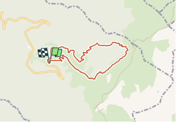

Length
7.6 km

Max alt
2017 m

Uphill gradient
641 m
Km-Effort
16.2 km

Min alt
1475 m

Downhill gradient
641 m
Boucle
Yes
Creation date :
2023-10-20 08:30:45.956
Updated on :
2023-10-20 08:31:55.85
3h40
Difficulty : Difficult

FREE GPS app for hiking
 SityTrail
IGN / Geographical institutes
SityTrail Plus
The world is yours!
About
Trail Walking of 7.6 km to be discovered at Auvergne-Rhône-Alpes, Savoy, Arvillard. This trail is proposed by lionelnottat.
Positioning
Country:
France
Region :
Auvergne-Rhône-Alpes
Department/Province :
Savoy
Municipality :
Arvillard
Location:
Unknown
Start:(Dec)
Start:(UTM)
278563 ; 5033374 (32T) N.
Comments