


Beynac

jcm17
User
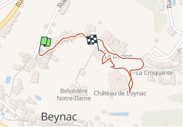

Length
418 m

Max alt
158 m

Uphill gradient
38 m
Km-Effort
821 m

Min alt
121 m

Downhill gradient
7 m
Boucle
Yes
Creation date :
2023-10-15 14:32:11.78
Updated on :
2023-10-22 09:09:06.976
38m
Difficulty : Easy

FREE GPS app for hiking
 SityTrail
IGN / Geographical institutes
SityTrail Plus
The world is yours!
About
Trail Walking of 418 m to be discovered at New Aquitaine, Dordogne, Beynac-et-Cazenac. This trail is proposed by jcm17.
Positioning
Country:
France
Region :
New Aquitaine
Department/Province :
Dordogne
Municipality :
Beynac-et-Cazenac
Location:
Unknown
Start:(Dec)
Start:(UTM)
353300 ; 4966923 (31T) N.
Comments