


guebwiller

heurtinpatrick
User
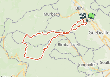

Length
17.5 km

Max alt
971 m

Uphill gradient
885 m
Km-Effort
29 km

Min alt
331 m

Downhill gradient
888 m
Boucle
Yes
Creation date :
2023-10-22 07:15:13.178
Updated on :
2023-10-22 14:39:09.155
5h03
Difficulty : Very difficult

FREE GPS app for hiking
 SityTrail
IGN / Geographical institutes
SityTrail Plus
The world is yours!
About
Trail Walking of 17.5 km to be discovered at Grand Est, Haut-Rhin, Guebwiller. This trail is proposed by heurtinpatrick.
Positioning
Country:
France
Region :
Grand Est
Department/Province :
Haut-Rhin
Municipality :
Guebwiller
Location:
Unknown
Start:(Dec)
Start:(UTM)
365288 ; 5308615 (32T) N.
Comments