Trail Other activity Saint-Étienne - Voie verte BIS - Photo
 papy43
papy43

User

© OpenStreetMap contributors
Length
Length
5.3 km
Max alt
Max alt
620 m
Uphill gradient
Uphill gradient
162 m
Km-Effort
Km-Effort  
7.4 km
Min alt
Min alt
541 m
Downhill gradient
Downhill gradient
135 m
Boucle
Boucle
No
Creation date :
2018-04-11 05:46:09.442
Updated on :
2018-04-11 05:46:09.442

(0 Reviews)

Other activity
Other activity
1h30
Difficulty : Unknown

Scan this QR Code to open this trail in the SityTrail application

FREE GPS app for hiking

Logo SityTrail SityTrail

IGN / Geographical institutes

Download SityTrail from the App Store Download SityTrail from Google Play

Logo SityTrail SityTrail World

The world is yours!

Download SityTrail from the App Store Download SityTrail from Google Play Download SityTrail on Huawei AppGallery

About

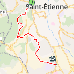
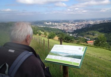
Trail Other activity of 5.3 km to be discovered at Auvergne-Rhône-Alpes, Loire, Saint-Étienne. This trail is proposed by papy43.

Description

Partie sud de la voie verte qui traverse Saint Etienne du nord au sud Partie Couriot Bellevue

Elevation profile

Positioning

Country:
France
Region :
Auvergne-Rhône-Alpes
Department/Province :
Loire
Municipality :
Saint-Étienne
Location:
Unknown
Start:(UTM)
607623 ; 5032658 (31T) N.

Trails nearby

Trail Mountain bike Saint-Genest-Lerpt - Rando VTT Les Balades d'automne - Saint Genest Lerpt - Photo
Mountain bike
tracegps

Mountain bike

Very difficult
(1)
Saint-Genest-Lerpt, Auvergne-Rhône-Alpes, Loire, France
49 km | 63 km-effort
3h 30min
Yes
Trail On foot Saint-Étienne - Voie Verte Terrasse-Bellevue - Photo
On foot
PRO

On foot

Easy
Saint-Étienne, Auvergne-Rhône-Alpes, Loire, France
10.8 km | 14.6 km-effort
3h 18min
No
Trail Motor Villars - Loire, Haute Loire, Ardèche - Photo
Motor
acsglaurent

Motor

Easy
(1)
Villars, Auvergne-Rhône-Alpes, Loire, France
342 km | 442 km-effort
5h 0min
Yes
Trail Walking Saint-Étienne - Château de Rochetaillé  - Photo
Walking
dudu42

Walking

Easy
Saint-Étienne, Auvergne-Rhône-Alpes, Loire, France
4.9 km | 7.7 km-effort
1h 15min
Yes
Trail Walking Saint-Étienne - Le tour du bois D'aveze - Photo
Walking
Domdomii

Walking

Very easy
Saint-Étienne, Auvergne-Rhône-Alpes, Loire, France
3.7 km | 5.3 km-effort
1h 31min
Yes
Trail Walking Saint-Étienne - st Étienne -le bessat - Photo
Walking
stefp42

Walking

Medium
(1)
Saint-Étienne, Auvergne-Rhône-Alpes, Loire, France
32 km | 45 km-effort
6h 4min
Yes
Trail Running Saint-Étienne - SaintéLyon - Photo
Running
sofracoan

Running

Medium
(1)
Saint-Étienne, Auvergne-Rhône-Alpes, Loire, France
72 km | 98 km-effort
10h 0min
No
Trail Other activity Saint-Étienne - St Etienne - Photo
Other activity
GPit42

Other activity

Very easy
Saint-Étienne, Auvergne-Rhône-Alpes, Loire, France
10.5 km | 15.2 km-effort
2h 46min
Yes
Trail Walking Saint-Étienne - Marche portail rouge - Photo
Walking
ramsay

Walking

Easy
(1)
Saint-Étienne, Auvergne-Rhône-Alpes, Loire, France
7.5 km | 11.2 km-effort
2h 25min
Yes


Close
My subscriptions