Trail Walking Ensuès-la-Redonne - Ensuez la redonne vers Niolon - Photo
© OpenStreetMap contributors
Length
Length
6.8 km
Max alt
Max alt
96 m
Uphill gradient
Uphill gradient
262 m
Km-Effort
Km-Effort  
10 km
Min alt
Min alt
3 m
Downhill gradient
Downhill gradient
201 m
Boucle
Boucle
No
Creation date :
2023-10-23 08:36:24.329
Updated on :
2023-10-23 09:13:45.542

(0 Reviews)

Walking
Walking
2h16
Difficulty : Medium

Scan this QR Code to open this trail in the SityTrail application

FREE GPS app for hiking

Logo SityTrail SityTrail

IGN / Geographical institutes

Download SityTrail from the App Store Download SityTrail from Google Play

Logo SityTrail SityTrail World

The world is yours!

Download SityTrail from the App Store Download SityTrail from Google Play Download SityTrail on Huawei AppGallery

About

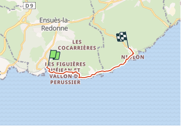
Trail Walking of 6.8 km to be discovered at Provence-Alpes-Côte d'Azur, Bouches-du-Rhône, Ensuès-la-Redonne. This trail is proposed by Fayolle Chantal.

Description

Randonnée assez difficile car montées et descentes avec marches et parfois caillouteux. 2eme partie assez glissante et parfois vertigineuse  entre la plage de l'èrevine et Niolon.
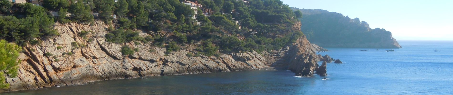
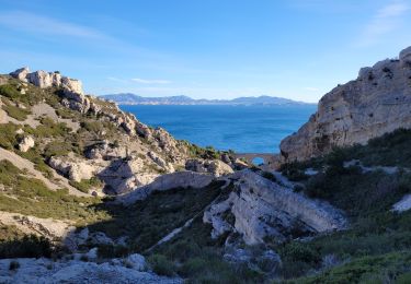
Mais la beauté du paysage vaut le détour.

Elevation profile

Photos

Positioning

Country:
France
Region :
Provence-Alpes-Côte d'Azur
Department/Province :
Bouches-du-Rhône
Municipality :
Ensuès-la-Redonne
Location:
Unknown
Start:(UTM)
678285 ; 4800331 (31T) N.

Trails nearby

Trail Walking Le Rove - Calanque de la Vesse - Niolon la Vesse - Photo
Walking
tracegps

Walking

Medium
(1)
Le Rove, Provence-Alpes-Côte d'Azur, Bouches-du-Rhône, France
5.7 km | 8.3 km-effort
2h 15min
Yes
Trail Walking Le Rove - Côté bleue  - Photo
Walking
GUIDE
nadinebondoux

Walking

Difficult
Le Rove, Provence-Alpes-Côte d'Azur, Bouches-du-Rhône, France
13.2 km | 18.7 km-effort
4h 39min
Yes
Trail On foot Carry-le-Rouet - Le Vallon de Jaume par les Grottes - Photo
On foot
PRO

On foot

Easy
Carry-le-Rouet, Provence-Alpes-Côte d'Azur, Bouches-du-Rhône, France
7.5 km | 10.2 km-effort
2h 19min
No
Trail On foot Carry-le-Rouet - Le Tour du Romaron - Photo
On foot
PRO

On foot

Easy
Carry-le-Rouet, Provence-Alpes-Côte d'Azur, Bouches-du-Rhône, France
7.3 km | 10 km-effort
2h 15min
No
Trail On foot Carry-le-Rouet - Entre calanques et collines - Photo
On foot
PRO

On foot

Easy
Carry-le-Rouet, Provence-Alpes-Côte d'Azur, Bouches-du-Rhône, France
11.8 km | 14.6 km-effort
3h 19min
No
Trail On foot Ensuès-la-Redonne - Grand Sentier de la Côte Bleue - Photo
On foot
PRO

On foot

Very difficult
Ensuès-la-Redonne, Provence-Alpes-Côte d'Azur, Bouches-du-Rhône, France
50 km | 60 km-effort
13h 34min
No
Trail On foot Le Rove - Le fort de Niolon - Photo
On foot
PRO

On foot

Easy
Le Rove, Provence-Alpes-Côte d'Azur, Bouches-du-Rhône, France
4.2 km | 6.6 km-effort
1h 29min
Yes
Trail Walking Le Rove - de Niolon à l'Erévine - Photo
Walking
GUIDE
amiral13

Walking

Easy
(1)
Le Rove, Provence-Alpes-Côte d'Azur, Bouches-du-Rhône, France
7.3 km | 11.1 km-effort
2h 47min
Yes
Trail Walking Le Rove - Cote bleue - Photo
Walking
GUIDE
nadinebondoux

Walking

Difficult
Le Rove, Provence-Alpes-Côte d'Azur, Bouches-du-Rhône, France
18.7 km | 26 km-effort
6h 48min
Yes


Close
My subscriptions