


Vauvenargues Chemin de la Marquise 25 octobre 2023

rlebasque
User
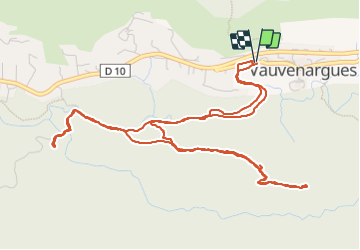

Length
7.6 km

Max alt
501 m

Uphill gradient
229 m
Km-Effort
10.7 km

Min alt
358 m

Downhill gradient
229 m
Boucle
Yes
Creation date :
2023-10-25 07:51:18.779
Updated on :
2023-10-25 10:01:53.894
2h10
Difficulty : Medium

FREE GPS app for hiking
 SityTrail
IGN / Geographical institutes
SityTrail Plus
The world is yours!
About
Trail Walking of 7.6 km to be discovered at Provence-Alpes-Côte d'Azur, Bouches-du-Rhône, Vauvenargues. This trail is proposed by rlebasque.
Positioning
Country:
France
Region :
Provence-Alpes-Côte d'Azur
Department/Province :
Bouches-du-Rhône
Municipality :
Vauvenargues
Location:
Unknown
Start:(Dec)
Start:(UTM)
710026 ; 4825780 (31T) N.
Comments