


Vingrau

caccini
User
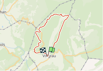

Length
15 km

Max alt
551 m

Uphill gradient
488 m
Km-Effort
22 km

Min alt
142 m

Downhill gradient
493 m
Boucle
Yes
Creation date :
2023-10-29 08:05:23.36
Updated on :
2023-10-30 08:20:07.698
4h53
Difficulty : Very difficult

FREE GPS app for hiking
 SityTrail
IGN / Geographical institutes
SityTrail Plus
The world is yours!
About
Trail Walking of 15 km to be discovered at Occitania, Pyrénées-Orientales, Vingrau. This trail is proposed by caccini.
Description
La Serre de Vingrau
Positioning
Country:
France
Region :
Occitania
Department/Province :
Pyrénées-Orientales
Municipality :
Vingrau
Location:
Unknown
Start:(Dec)
Start:(UTM)
481820 ; 4744048 (31T) N.
Comments