


Tetouan

Etienneh57
User
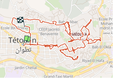

Length
7.3 km

Max alt
111 m

Uphill gradient
66 m
Km-Effort
8.2 km

Min alt
69 m

Downhill gradient
64 m
Boucle
No
Creation date :
2023-10-30 09:15:15.0
Updated on :
2023-11-01 12:16:44.671

FREE GPS app for hiking
 SityTrail
IGN / Geographical institutes
SityTrail World
The world is yours!
About
Trail of 7.3 km to be discovered at Tangier-Tetouan-Al Hoceima, Tétouan. This trail is proposed by Etienneh57.
Description
Visite de tetouan
Positioning
Country:
Morocco
Region :
Tangier-Tetouan-Al Hoceima
Department/Province :
Tétouan
Municipality :
Unknown
Location:
Unknown
Start:(Dec)
Start:(UTM)
284847 ; 3938855 (30S) N.
Comments
Trails nearby