Trail Walking Communay - communay 1 - Photo
 AlixJ3
AlixJ3

User

© OpenStreetMap contributors
Length
Length
16 km
Max alt
Max alt
287 m
Uphill gradient
Uphill gradient
292 m
Km-Effort
Km-Effort  
19.9 km
Min alt
Min alt
202 m
Downhill gradient
Downhill gradient
294 m
Boucle
Boucle
Yes
Creation date :
2023-11-03 14:39:05.423
Updated on :
2023-11-04 10:50:19.028

(0 Reviews)

Walking
Walking
4h30
Difficulty : Very difficult

Scan this QR Code to open this trail in the SityTrail application

FREE GPS app for hiking

Logo SityTrail SityTrail

IGN / Geographical institutes

Download SityTrail from the App Store Download SityTrail from Google Play

Logo SityTrail SityTrail World

The world is yours!

Download SityTrail from the App Store Download SityTrail from Google Play Download SityTrail on Huawei AppGallery

About

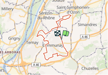
Trail Walking of 16 km to be discovered at Auvergne-Rhône-Alpes, Rhône, Communay. This trail is proposed by AlixJ3.

Description

vers St Symphorien et le Grand clos Ternay

Elevation profile

Positioning

Country:
France
Region :
Auvergne-Rhône-Alpes
Department/Province :
Rhône
Municipality :
Communay
Location:
Unknown
Start:(UTM)
643681 ; 5052223 (31T) N.

Trails nearby

Trail Walking Vernaison - 69-Vernaisonlesforts12km170m - Photo
Walking
SyMA

Walking

Medium
Vernaison, Auvergne-Rhône-Alpes, Métropole de Lyon, France
12.4 km | 14.7 km-effort
3h 25min
Yes
Trail Walking Millery - Exercice trace - Photo
Walking
Jean-Marc Gally

Walking

Easy
(1)
Millery, Auvergne-Rhône-Alpes, Rhône, France
2.1 km | 2.5 km-effort
33min
No
Trail Walking Communay - balade notre dame de linon  - Photo
Walking
Swyn

Walking

Easy
Communay, Auvergne-Rhône-Alpes, Rhône, France
4.9 km | 7.2 km-effort
2h 7min
Yes
Trail Mountain bike Vernaison - first test - Photo
Mountain bike
beb69

Mountain bike

Very easy
(2)
Vernaison, Auvergne-Rhône-Alpes, Métropole de Lyon, France
21 km | 27 km-effort
1h 5min
Yes
Trail Mountain bike Simandres - Simandres - Communay la Châtaigneraie - Chaponnay - Photo
Mountain bike
tracegps

Mountain bike

Difficult
Simandres, Auvergne-Rhône-Alpes, Rhône, France
25 km | 31 km-effort
2h 30min
Yes
Trail Mountain bike Chasse-sur-Rhône - Chasse-Chuzelles-Villette - Photo
Mountain bike
tracegps

Mountain bike

Difficult
Chasse-sur-Rhône, Auvergne-Rhône-Alpes, Isère, France
38 km | 49 km-effort
3h 0min
Yes
Trail Mountain bike Vernaison - charly - Photo
Mountain bike
marc6262

Mountain bike

Difficult
Vernaison, Auvergne-Rhône-Alpes, Métropole de Lyon, France
54 km | 69 km-effort
3h 48min
No
Trail Walking Vernaison - De vergers en pâturages N°3 Topo Grand Lyon à pied - Photo
Walking
chuck

Walking

Easy
Vernaison, Auvergne-Rhône-Alpes, Métropole de Lyon, France
15.2 km | 18 km-effort
4h 5min
Yes
Trail Walking Vernaison - grigny - Photo
Walking
cacrhone

Walking

Medium
Vernaison, Auvergne-Rhône-Alpes, Métropole de Lyon, France
8.8 km | 9.6 km-effort
2h 28min
Yes


Close
My subscriptions