![](/images/other/stat-length.png)
![Trail Walking Toulon-sur-Arroux - Toulon sur Arroux les berges - Photo](https://media.geolcdn.com/t/1900/400/ext.pjpeg?maxdim=2&url=https%3A%2F%2Fstatic1.geolcdn.com%2Fsiteimages%2Fupload%2Ffiles%2F1553511878bg_sport_marche.png)
Toulon sur Arroux les berges
PASSION RANDO
Marcher en groupe en veillant au respect de chacun et à la bonne humeur.
![Length](/images/other/stat-length.png)
Length
9 km
![Max alt](https://static1.geolcdn.com/siteimages/upload/files/1508320355ic_sort_altitude_max_24dp.png)
Max alt
349 m
![Uphill gradient](https://static1.geolcdn.com/siteimages/upload/files/1508320355ic_sort_den_pos_24dp.png)
Uphill gradient
124 m
![Km-Effort](/images/other/stat-length.png)
Km-Effort
10.7 km
![Min alt](https://static1.geolcdn.com/siteimages/upload/files/1508320355ic_sort_altitude_min_24dp.png)
Min alt
249 m
![Downhill gradient](https://static1.geolcdn.com/siteimages/upload/files/1508320355ic_sort_den_neg_24dp.png)
Downhill gradient
124 m
![Boucle](https://static1.geolcdn.com/siteimages/upload/files/16400158638029165_repeat_loop_refresh_sync_direction_icon.png)
Boucle
Yes
Creation date :
2023-11-08 09:16:53.622
Updated on :
2024-02-25 06:32:05.774
![Walking](https://static1.geolcdn.com/sitytour/trail-icons/101.png)
2h25
Difficulty : Medium
![Scan this QR Code to open this trail in the SityTrail application](https://capi.geolives.com/qq0zvz2zws4bq2lad0pu/sitytour/trails/3861357/qr.png?size=200)
FREE GPS app for hiking
About
Trail Walking of 9 km to be discovered at Bourgogne-Franche-Comté, Saône-et-Loire, Toulon-sur-Arroux. This trail is proposed by PASSION RANDO.
Description
circuit A/R
départ Moulin des Roches
Positioning
Country:
France
Region :
Bourgogne-Franche-Comté
Department/Province :
Saône-et-Loire
Municipality :
Toulon-sur-Arroux
Location:
Unknown
Start:(Dec)
Start:(UTM)
586816 ; 5171748 (31T) N.
Comments
Trails nearby
![Trail Walking Saint-Eugène - St Eugene GRS M-MNT - Photo](https://media.geolcdn.com/t/375/260/ext.jpg?maxdim=2&url=https%3A%2F%2Fstatic1.geolcdn.com%2Fsiteimages%2Fupload%2Ffiles%2F1553511878bg_sport_marche.png)
![Walking Walking](https://static1.geolcdn.com/sitytour/trail-icons/101.png)
St Eugene GRS M-MNT
Walking
Medium
(1)
Saint-Eugène,
Bourgogne-Franche-Comté,
Saône-et-Loire,
France
![](/images/other/stat-length.png)
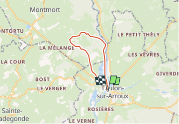
11.7 km | 15.5 km-effort
3h 31min
![](https://static1.geolcdn.com/siteimages/upload/files/16400158638029165_repeat_loop_refresh_sync_direction_icon.png)
Yes
![Trail Walking Montmort - RANDO Montmort Le Mont - Photo](https://media.geolcdn.com/t/375/260/ext.jpg?maxdim=2&url=https%3A%2F%2Fmedia.geolcdn.com%2Ff%2Fae155018-61d6-486d-9b05-d824c27d837e.jpg)
![Walking Walking](https://static1.geolcdn.com/sitytour/trail-icons/101.png)
RANDO Montmort Le Mont
Walking
Medium
Montmort,
Bourgogne-Franche-Comté,
Saône-et-Loire,
France
![](/images/other/stat-length.png)
8.1 km | 10.1 km-effort
2h 17min
![](https://static1.geolcdn.com/siteimages/upload/files/16400158638029165_repeat_loop_refresh_sync_direction_icon.png)
Yes
![Trail Walking Toulon-sur-Arroux - RANDO_La_Croix_Des_Autrichiens - Photo](https://media.geolcdn.com/t/375/260/ext.jpg?maxdim=2&url=https%3A%2F%2Fmedia.geolcdn.com%2Ff%2Fd5c8b2c6-3eeb-4245-8b0f-bdc1ac35bb43.jpg)
![Walking Walking](https://static1.geolcdn.com/sitytour/trail-icons/101.png)
RANDO_La_Croix_Des_Autrichiens
Walking
Easy
Toulon-sur-Arroux,
Bourgogne-Franche-Comté,
Saône-et-Loire,
France
![](/images/other/stat-length.png)
19.1 km | 24 km-effort
5h 27min
![](https://static1.geolcdn.com/siteimages/upload/files/16400158638029165_repeat_loop_refresh_sync_direction_icon.png)
Yes
![Trail Walking Montmort - RANDO Montmort Bois Du Nom - Photo](https://media.geolcdn.com/t/375/260/ext.jpg?maxdim=2&url=https%3A%2F%2Fmedia.geolcdn.com%2Ff%2F71032ac5-3824-4a45-9d7b-064bccd113d6.jpg)
![Walking Walking](https://static1.geolcdn.com/sitytour/trail-icons/101.png)
RANDO Montmort Bois Du Nom
Walking
Medium
(1)
Montmort,
Bourgogne-Franche-Comté,
Saône-et-Loire,
France
![](/images/other/stat-length.png)
6.8 km | 8.8 km-effort
1h 48min
![](https://static1.geolcdn.com/siteimages/upload/files/16400158638029165_repeat_loop_refresh_sync_direction_icon.png)
Yes
![Trail Walking Montmort - RANDO_Montmort_Bois_Du_Nom - Photo](https://media.geolcdn.com/t/375/260/ext.jpg?maxdim=2&url=https%3A%2F%2Fmedia.geolcdn.com%2Ff%2Fb56f9d65-862d-4a9d-be5d-5c56f989e92b.jpg)
![Walking Walking](https://static1.geolcdn.com/sitytour/trail-icons/101.png)
RANDO_Montmort_Bois_Du_Nom
Walking
Medium
Montmort,
Bourgogne-Franche-Comté,
Saône-et-Loire,
France
![](/images/other/stat-length.png)
10.8 km | 13.5 km-effort
3h 3min
![](https://static1.geolcdn.com/siteimages/upload/files/16400158638029165_repeat_loop_refresh_sync_direction_icon.png)
Yes
![Trail Walking Toulon-sur-Arroux - Bernard pluchot - Photo](https://media.geolcdn.com/t/375/260/ext.jpg?maxdim=2&url=https%3A%2F%2Fstatic1.geolcdn.com%2Fsiteimages%2Fupload%2Ffiles%2F1553511878bg_sport_marche.png)
![Walking Walking](https://static1.geolcdn.com/sitytour/trail-icons/101.png)
Bernard pluchot
Walking
Medium
Toulon-sur-Arroux,
Bourgogne-Franche-Comté,
Saône-et-Loire,
France
![](/images/other/stat-length.png)
7.5 km | 9.1 km-effort
2h 4min
![](https://static1.geolcdn.com/siteimages/upload/files/16400158638029165_repeat_loop_refresh_sync_direction_icon.png)
Yes
![Trail Walking Toulon-sur-Arroux - Toulon sur Arroux - Photo](https://media.geolcdn.com/t/375/260/ext.jpg?maxdim=2&url=https%3A%2F%2Fstatic1.geolcdn.com%2Fsiteimages%2Fupload%2Ffiles%2F1553511878bg_sport_marche.png)
![Walking Walking](https://static1.geolcdn.com/sitytour/trail-icons/101.png)
Toulon sur Arroux
Walking
Difficult
Toulon-sur-Arroux,
Bourgogne-Franche-Comté,
Saône-et-Loire,
France
![](/images/other/stat-length.png)
11.6 km | 13.8 km-effort
3h 8min
![](https://static1.geolcdn.com/siteimages/upload/files/16400158638029165_repeat_loop_refresh_sync_direction_icon.png)
Yes
![Trail Walking Toulon-sur-Arroux - Les Grands Vallots 30 déc. 2019 - Photo](https://media.geolcdn.com/t/375/260/ext.jpg?maxdim=2&url=https%3A%2F%2Fstatic1.geolcdn.com%2Fsiteimages%2Fupload%2Ffiles%2F1553511878bg_sport_marche.png)
![Walking Walking](https://static1.geolcdn.com/sitytour/trail-icons/101.png)
Les Grands Vallots 30 déc. 2019
Walking
Medium
Toulon-sur-Arroux,
Bourgogne-Franche-Comté,
Saône-et-Loire,
France
![](/images/other/stat-length.png)
8.9 km | 11.2 km-effort
2h 24min
![](https://static1.geolcdn.com/siteimages/upload/files/16400158638029165_repeat_loop_refresh_sync_direction_icon.png)
Yes
![Trail Walking Montmort - MONTMORT BOIS DU NOM - Photo](https://media.geolcdn.com/t/375/260/ext.jpg?maxdim=2&url=https%3A%2F%2Fstatic1.geolcdn.com%2Fsiteimages%2Fupload%2Ffiles%2F1553511878bg_sport_marche.png)
![Walking Walking](https://static1.geolcdn.com/sitytour/trail-icons/101.png)
MONTMORT BOIS DU NOM
Walking
Medium
Montmort,
Bourgogne-Franche-Comté,
Saône-et-Loire,
France
![](/images/other/stat-length.png)
8.9 km | 11.4 km-effort
2h 35min
![](https://static1.geolcdn.com/siteimages/upload/files/16400158638029165_repeat_loop_refresh_sync_direction_icon.png)
Yes