Trail Walking Cuges-les-Pins - du col de l'ange à la chapelle St Martin : Gémenos - Photo

du col de l'ange à la chapelle St Martin : Gémenos

© OpenStreetMap contributors
Length
Length
11.7 km
Max alt
Max alt
490 m
Uphill gradient
Uphill gradient
548 m
Km-Effort
Km-Effort  
19 km
Min alt
Min alt
216 m
Downhill gradient
Downhill gradient
548 m
Boucle
Boucle
Yes
Creation date :
2023-11-08 09:18:36.865
Updated on :
2023-11-08 09:27:23.615

(0 Reviews)

Walking
Walking
4h18
Difficulty : Difficult

Scan this QR Code to open this trail in the SityTrail application

FREE GPS app for hiking

Logo SityTrail SityTrail

IGN / Geographical institutes

Download SityTrail from the App Store Download SityTrail from Google Play

Logo SityTrail SityTrail World

The world is yours!

Download SityTrail from the App Store Download SityTrail from Google Play Download SityTrail on Huawei AppGallery

About

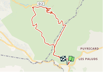
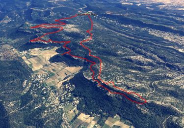
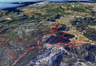
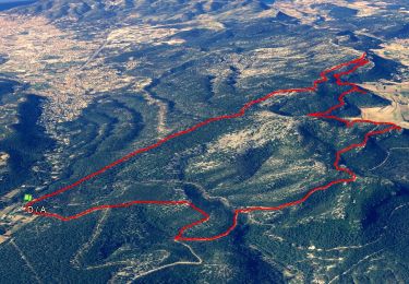
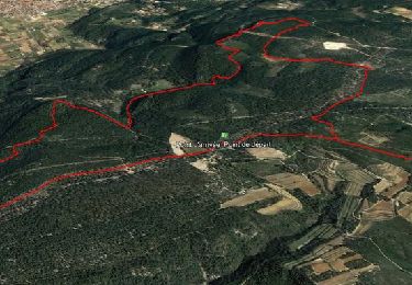
Trail Walking of 11.7 km to be discovered at Provence-Alpes-Côte d'Azur, Bouches-du-Rhône, Cuges-les-Pins. This trail is proposed by eaea7charles.

Description

départ du parking du col de l'ange sur la RN8 vers le sommet du Brigou sur le GR 98, puis la chapelle St Martin le long du torrent de fouge. Retour vers le mont cruvelier

Elevation profile

Positioning

Country:
France
Region :
Provence-Alpes-Côte d'Azur
Department/Province :
Bouches-du-Rhône
Municipality :
Cuges-les-Pins
Location:
Unknown
Start:(UTM)
716681 ; 4793793 (31T) N.

Trails nearby

Trail Walking Roquefort-la-Bédoule - Grand Caunet, le Montounier - Photo
Walking
GUIDE
affinetataille

Walking

Medium
(1)
Roquefort-la-Bédoule, Provence-Alpes-Côte d'Azur, Bouches-du-Rhône, France
16.5 km | 24 km-effort
6h 0min
Yes
Trail Walking Ceyreste - Autour du Montounier 2eme version - Photo
Walking
GUIDE
affinetataille

Walking

Medium
(1)
Ceyreste, Provence-Alpes-Côte d'Azur, Bouches-du-Rhône, France
15.7 km | 24 km-effort
6h 0min
Yes
Trail Walking Roquefort-la-Bédoule - SityTrail - Grand Caunet, Cabanons, Vigie , Grotte Raymond, Ruines roquefort, Chapelle St andré - Photo
Walking
GUIDE
affinetataille

Walking

Easy
(1)
Roquefort-la-Bédoule, Provence-Alpes-Côte d'Azur, Bouches-du-Rhône, France
14.2 km | 19.9 km-effort
6h 0min
Yes
Trail Walking Le Castellet - SityTrail - 2361987 - begude - Photo
Walking
GUIDE
affinetataille

Walking

Medium
(1)
Le Castellet, Provence-Alpes-Côte d'Azur, Var, France
11.5 km | 15.1 km-effort
4h 0min
Yes
Trail Walking Gémenos - St Pons Le Fauge Glacière  - Photo
Walking
GUIDE
lhomme.ph

Walking

Difficult
(1)
Gémenos, Provence-Alpes-Côte d'Azur, Bouches-du-Rhône, France
11.7 km | 18.6 km-effort
3h 56min
Yes
Trail Walking Roquefort-la-Bédoule - la petite sainte baume - Photo
Walking
Coryphene

Walking

Easy
(1)
Roquefort-la-Bédoule, Provence-Alpes-Côte d'Azur, Bouches-du-Rhône, France
13.9 km | 19.3 km-effort
5h 37min
Yes
Trail Walking Gémenos - autour de Saint pons - Photo
Walking
Coryphene

Walking

Easy
(1)
Gémenos, Provence-Alpes-Côte d'Azur, Bouches-du-Rhône, France
11.6 km | 16.1 km-effort
3h 46min
Yes
Trail Mountain bike Gémenos - Gémenos - La Grande Baume - Photo
Mountain bike
tracegps

Mountain bike

Difficult
(1)
Gémenos, Provence-Alpes-Côte d'Azur, Bouches-du-Rhône, France
18.4 km | 29 km-effort
3h 30min
Yes
Trail Walking Roquefort-la-Bédoule - Barres de Font Blanche - Photo
Walking
tracegps

Walking

Medium
(1)
Roquefort-la-Bédoule, Provence-Alpes-Côte d'Azur, Bouches-du-Rhône, France
10.3 km | 14.4 km-effort
2h 19min
Yes


Close
My subscriptions