Trail Walking Nice - Balade Niçoise : Centre-Ville, Vieux-Nice, Le Port - Photo

Balade Niçoise : Centre-Ville, Vieux-Nice, Le Port

© OpenStreetMap contributors
Length
Length
5.4 km
Max alt
Max alt
72 m
Uphill gradient
Uphill gradient
135 m
Km-Effort
Km-Effort  
7.2 km
Min alt
Min alt
-2 m
Downhill gradient
Downhill gradient
134 m
Boucle
Boucle
Yes
Creation date :
2023-11-11 13:57:23.0
Updated on :
2023-11-11 17:14:08.411

(0 Reviews)

Walking
Walking
2h30
Difficulty : Very easy

Scan this QR Code to open this trail in the SityTrail application

FREE GPS app for hiking

Logo SityTrail SityTrail

IGN / Geographical institutes

Download SityTrail from the App Store Download SityTrail from Google Play

Logo SityTrail SityTrail World

The world is yours!

Download SityTrail from the App Store Download SityTrail from Google Play Download SityTrail on Huawei AppGallery

About

Trail Walking of 5.4 km to be discovered at Provence-Alpes-Côte d'Azur, Maritime Alps, Nice. This trail is proposed by LightStalker.
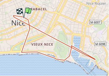
Description

Distance : 5.8 Km
Dénivelé :   137 m
Temps : 2h24mn

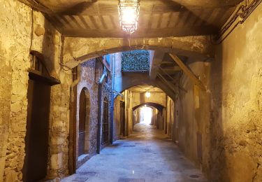
Balade niçoise au travers des principaux quartiers : Centre-Ville, Vieux-Nice, Le Port en longeant une partie de la côte par la Promenade des Anglais jusqu’au Port et en rentrant en tramway (ligne T2 de Port Lympia à Jean Médecin).
Pas un souvenir impérissable car la population fait match-vu, la ville manque de verdure, l’urbanisme est chaotique et surtout, la ville n’a pas d’âme. Rien ne vibre même pas la mer et les rochers !

Elevation profile

Photos

Positioning

Country:
France
Region :
Provence-Alpes-Côte d'Azur
Department/Province :
Maritime Alps
Municipality :
Nice
Location:
Unknown
Start:(Dec)
Start:(UTM)
360605 ; 4840226 (32T) N.

Trails nearby

Trail Walking Nice - Ballade chemin des douaniers Nice-Villefranche  - Photo
Walking
coriace

Walking

Very easy
(1)
Nice, Provence-Alpes-Côte d'Azur, Maritime Alps, France
7.9 km | 10.3 km-effort
2h 13min
No
Trail Walking Nice - Collines niçoises - Photo
Walking
kenhava

Walking

Easy
(1)
Nice, Provence-Alpes-Côte d'Azur, Maritime Alps, France
21 km | 30 km-effort
6h 32min
No
Trail Walking Saint-Jean-Cap-Ferrat - Cap Ferrat 2011-10-27 - Photo
Walking
Cricounet84

Walking

Medium
(2)
Saint-Jean-Cap-Ferrat, Provence-Alpes-Côte d'Azur, Maritime Alps, France
10.9 km | 14 km-effort
4h 0min
Yes
Trail Walking Nice - Nice - Tour du Mont Boron - Photo
Walking
LightStalker

Walking

Easy
Nice, Provence-Alpes-Côte d'Azur, Maritime Alps, France
7.3 km | 10.5 km-effort
2h 48min
Yes
Trail Walking Falicon - Pyramide de Nice Falicon - Photo
Walking
jll7513

Walking

Easy
Falicon, Provence-Alpes-Côte d'Azur, Maritime Alps, France
4 km | 6 km-effort
1h 7min
Yes
Trail Walking Villefranche-sur-Mer - Tour_de_St_Jean_au_départ_des_Marinières-14087858-1641299736-752 - Photo
Walking
Renefrt

Walking

Easy
(1)
Villefranche-sur-Mer, Provence-Alpes-Côte d'Azur, Maritime Alps, France
12.3 km | 15.2 km-effort
3h 26min
Yes
Trail Walking Nice - Vieux Nice- Beaulieu par la côte  - Photo
Walking
coriace

Walking

Easy
(1)
Nice, Provence-Alpes-Côte d'Azur, Maritime Alps, France
18.1 km | 23 km-effort
3h 57min
No
Trail Walking Nice - BORON - Photo
Walking
Benteux

Walking

Very easy
Nice, Provence-Alpes-Côte d'Azur, Maritime Alps, France
12.7 km | 17.5 km-effort
5h 51min
Yes
Trail Walking Nice - Nice Mont Boron, Mont Alban, cap de Nice - Photo
Walking
reneperrin

Walking

Easy
Nice, Provence-Alpes-Côte d'Azur, Maritime Alps, France
17.1 km | 22 km-effort
3h 59min
No


Close
My subscriptions