


Trace G4 Ossas Suhare Guy

mitch1952
User
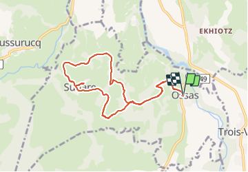

Length
9.8 km

Max alt
312 m

Uphill gradient
251 m
Km-Effort
13.1 km

Min alt
192 m

Downhill gradient
252 m
Boucle
Yes
Creation date :
2023-11-17 08:33:22.0
Updated on :
2023-11-17 13:39:30.476
5h03
Difficulty : Unknown

FREE GPS app for hiking
 SityTrail
IGN / Geographical institutes
SityTrail Plus
The world is yours!
About
Trail Walking of 9.8 km to be discovered at New Aquitaine, Pyrénées-Atlantiques, Ossas-Suhare. This trail is proposed by mitch1952.
Positioning
Country:
France
Region :
New Aquitaine
Department/Province :
Pyrénées-Atlantiques
Municipality :
Ossas-Suhare
Location:
Unknown
Start:(Dec)
Start:(UTM)
671501 ; 4778572 (30T) N.
Comments