


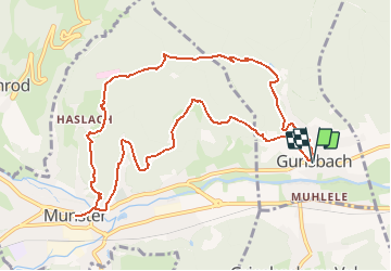
Gunsbach-Kaiserbrunnen-Munster-Kaltbach-Gunsbach

patrickbeyrath
User

Length
10.9 km

Max alt
697 m

Uphill gradient
489 m
Km-Effort
17.4 km

Min alt
348 m

Downhill gradient
491 m
Boucle
Yes
Creation date :
2018-10-13 05:52:46.888
Updated on :
2018-10-13 05:52:46.895
3h41
Difficulty : Medium

FREE GPS app for hiking
 SityTrail
IGN / Geographical institutes
SityTrail Plus
The world is yours!
About
Trail Walking of 10.9 km to be discovered at Grand Est, Haut-Rhin, Gunsbach. This trail is proposed by patrickbeyrath.
Positioning
Country:
France
Region :
Grand Est
Department/Province :
Haut-Rhin
Municipality :
Gunsbach
Location:
Unknown
Start:(Dec)
Start:(UTM)
363983 ; 5323080 (32U) N.
Comments