


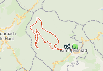
Parking Mairie de Rammersmatt - Spannplatz - Kaschelbach - Abri Hochburg et retour

patrickbeyrath
User

Length
8 km

Max alt
717 m

Uphill gradient
293 m
Km-Effort
11.9 km

Min alt
492 m

Downhill gradient
293 m
Boucle
Yes
Creation date :
2023-11-30 08:25:43.95
Updated on :
2023-12-01 06:09:31.748
2h49
Difficulty : Medium

FREE GPS app for hiking
 SityTrail
IGN / Geographical institutes
SityTrail Plus
The world is yours!
About
Trail Walking of 8 km to be discovered at Grand Est, Haut-Rhin, Rammersmatt. This trail is proposed by patrickbeyrath.
Positioning
Country:
France
Region :
Grand Est
Department/Province :
Haut-Rhin
Municipality :
Rammersmatt
Location:
Unknown
Start:(Dec)
Start:(UTM)
355336 ; 5294693 (32T) N.
Comments