


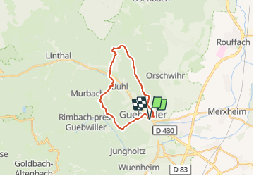
Le tour de Guebwiller

Alain28/01
User

Length
19.3 km

Max alt
629 m

Uphill gradient
667 m
Km-Effort
28 km

Min alt
282 m

Downhill gradient
667 m
Boucle
Yes
Creation date :
2023-12-04 11:01:19.563
Updated on :
2023-12-04 11:02:43.662
6h24
Difficulty : Medium

FREE GPS app for hiking
 SityTrail
IGN / Geographical institutes
SityTrail Plus
The world is yours!
About
Trail Walking of 19.3 km to be discovered at Grand Est, Haut-Rhin, Guebwiller. This trail is proposed by Alain28/01.
Positioning
Country:
France
Region :
Grand Est
Department/Province :
Haut-Rhin
Municipality :
Guebwiller
Location:
Unknown
Start:(Dec)
Start:(UTM)
366824 ; 5307407 (32T) N.
Comments