


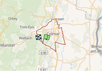
2015 02 25 Tour de Colmar

staubalex
User

Length
45 km

Max alt
242 m

Uphill gradient
282 m
Km-Effort
49 km

Min alt
179 m

Downhill gradient
279 m
Boucle
Yes
Creation date :
2015-02-22 00:00:00.0
Updated on :
2015-02-22 00:00:00.0
3h16
Difficulty : Difficult

FREE GPS app for hiking
 SityTrail
IGN / Geographical institutes
SityTrail Plus
The world is yours!
About
Trail Other activity of 45 km to be discovered at Grand Est, Haut-Rhin, Eguisheim. This trail is proposed by staubalex.
Positioning
Country:
France
Region :
Grand Est
Department/Province :
Haut-Rhin
Municipality :
Eguisheim
Location:
Unknown
Start:(Dec)
Start:(UTM)
373949 ; 5322803 (32U) N.
Comments