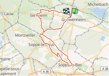
Guewenheim Sentheim Soppe le bas

Alain28/01
User

Length
18.9 km

Max alt
392 m

Uphill gradient
241 m
Km-Effort
22 km

Min alt
307 m

Downhill gradient
240 m
Boucle
Yes
Creation date :
2023-12-10 09:57:40.517
Updated on :
2023-12-10 10:35:46.92
5h01
Difficulty : Medium
5h01
Difficulty : Medium

FREE GPS app for hiking
 SityTrail
IGN / Geographical institutes
SityTrail Plus
The world is yours!
About
Trail On foot of 18.9 km to be discovered at Grand Est, Haut-Rhin, Guewenheim. This trail is proposed by Alain28/01.
Positioning
Country:
France
Region :
Grand Est
Department/Province :
Haut-Rhin
Municipality :
Guewenheim
Location:
Unknown
Start:(Dec)
Start:(UTM)
356853 ; 5290630 (32T) N.
Comments